Satellite Imagery to Measure Elevation Changes
Satellite Imagery to Measure Elevation Changes
A new study out of Tulane University uses satellite-based remote sensing to track changes in ground elevation.
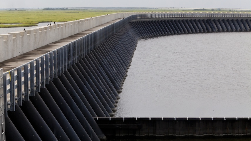
Thanks to the widespread flooding and damage caused by Hurricane Katrina, the Army Corps of Engineers started an ambitious infrastructure project, the Hurricane and Storm Damage Risk Reduction System (HSDRRS) in 2006. The project constructed a variety of protective structures, including levees, floodwalls, and pumping stations, to help keep the city and surrounding areas safe in the event of future storms or flooding.
There’s only one issue: new research from Tulane University suggests that the areas upon which these structures are built are gradually sinking.
Mead Allison, professor and chair at the Department of River-Coastal Science and Engineering at Tulane University, and colleagues used a remote sensing technique to measure subsidence, or the sinking of an area of land over time, called Interferometric Synthetic Aperture Radar (InSAR). InSAR utilizes orbiting satellites to capture radar images of the Earth’s surface. Radar waves have the power to penetrate most cloud systems, as well as capture images in darkness. Scientists can then compare those images over time to map ground deformation.
You May Want To Read: Space-Based Solar Power Offers Out-of-This World Challenges
Allison said he and his colleagues, including first author Simone Fiaschi, who is now at TRE-Altamira, first received funding from Louisiana’s Coastal Protection and Restoration Authority. This state entity is responsible for developing, implementing, and enforcing coastal protection. It is tasked with assessing whether InSAR is a feasible method for tracking subsidence in the wetlands surrounding New Orleans.
“One of the big unknowns is how fast the land is going down in coastal marshes,” he said. “We wanted to use InSAR, except that it’s quite challenging to use radar in wetlands as it just reflects off the water. There are also different canopy heights so the radar can sometimes bounce off the canopy instead of the ground. As a result, we decided we should start with an area that’s a little more accesible: New Orleans.”
“In the city, you can bounce the radar off buildings, roads, and other hard structures,” Allison explained. “You can get a lot more coherence…And as the satellite goes over the area every 12 days, we were able to effectively measure the ground elevation every 12 days, giving us literally hundreds of repeat measurements for each pixel on the ground.”
The research team utilized InSAR images from 2002 to 2020 to create a map of vertical land motion in the city. They discovered that the HSDRRS system, specifically developed to protect the city, was in some areas sinking to the point where those structures might become ineffective.
“We had a before and after comparison of the areas where the HSDRRS came in, which was interesting,” he said. “And some of those sections of land seem to be very stable, but other sections seem to be sinking at a significant rate. That raises an important question: What is the mechanism here?”
Relevant Reads: Tracking Subsidence to Unlock Coastal Stability
While Allison admitted that InSAR did not provide as much accuracy as a ground-based survey, it was not easy, nor cost-effective, to have conducted those sorts of surveys. Additionally, he noted that InSAR enables researchers to observe trend data, including changes in subsidence rates over a specific time period. It can also guide engineers and other infrastructure stakeholders on where they should conduct more in-depth ground-based analysis.
“The big question with some of these sections is why it’s going down. Maybe it’s just settling after the initial construction of these structures,” he said. “Maybe it’s not the flood wall that’s sinking but the apron made of earth next to it. But InSAR lets us know where we should look to figure out what might be happening.”
Allison and colleagues have recently completed an InSAR study of subsidence in the wetlands surrounding New Orleans and plan to publish that data soon. Even with the challenges of using radar in water, they were able to get some interesting data in the upland areas of the Mississippi delta.
Discover the Benefits of ASME Membership
“When we imaged all those fingers down the bayou where people built their communities, we saw the system is surprisingly stable,” he said. “The high ground next to the wetlands does not seem to be sinking significantly, which is encouraging.”
Yet, as they complete their work on that data, Allison said that InSAR is a valuable tool not just for New Orleans, but for other cities that are looking at investing in expensive storm/flooding protection systems.
“New York is planning something similar to the HSDRRS. And if nothing else, Hurricane Katrina got this very high-quality system built around New Orleans,” he explained. “But just building it isn’t enough, especially in areas subject to natural subsidence and rising sea levels. You have to have a way to keep tabs on what’s happening on the ground and the true level of protection you are getting from your system…InSAR is a very promising technique to help us monitor elevation relative to sea level and make important decisions about where you need to build protection for coastal communities and ecosystems.”
Kayt Sukel is a technology writer and author in Houston.
There’s only one issue: new research from Tulane University suggests that the areas upon which these structures are built are gradually sinking.
From satellites to storm protection
Mead Allison, professor and chair at the Department of River-Coastal Science and Engineering at Tulane University, and colleagues used a remote sensing technique to measure subsidence, or the sinking of an area of land over time, called Interferometric Synthetic Aperture Radar (InSAR). InSAR utilizes orbiting satellites to capture radar images of the Earth’s surface. Radar waves have the power to penetrate most cloud systems, as well as capture images in darkness. Scientists can then compare those images over time to map ground deformation.
You May Want To Read: Space-Based Solar Power Offers Out-of-This World Challenges
Allison said he and his colleagues, including first author Simone Fiaschi, who is now at TRE-Altamira, first received funding from Louisiana’s Coastal Protection and Restoration Authority. This state entity is responsible for developing, implementing, and enforcing coastal protection. It is tasked with assessing whether InSAR is a feasible method for tracking subsidence in the wetlands surrounding New Orleans.
“One of the big unknowns is how fast the land is going down in coastal marshes,” he said. “We wanted to use InSAR, except that it’s quite challenging to use radar in wetlands as it just reflects off the water. There are also different canopy heights so the radar can sometimes bounce off the canopy instead of the ground. As a result, we decided we should start with an area that’s a little more accesible: New Orleans.”
“In the city, you can bounce the radar off buildings, roads, and other hard structures,” Allison explained. “You can get a lot more coherence…And as the satellite goes over the area every 12 days, we were able to effectively measure the ground elevation every 12 days, giving us literally hundreds of repeat measurements for each pixel on the ground.”
Sinking concerns
The research team utilized InSAR images from 2002 to 2020 to create a map of vertical land motion in the city. They discovered that the HSDRRS system, specifically developed to protect the city, was in some areas sinking to the point where those structures might become ineffective.
“We had a before and after comparison of the areas where the HSDRRS came in, which was interesting,” he said. “And some of those sections of land seem to be very stable, but other sections seem to be sinking at a significant rate. That raises an important question: What is the mechanism here?”
Relevant Reads: Tracking Subsidence to Unlock Coastal Stability
While Allison admitted that InSAR did not provide as much accuracy as a ground-based survey, it was not easy, nor cost-effective, to have conducted those sorts of surveys. Additionally, he noted that InSAR enables researchers to observe trend data, including changes in subsidence rates over a specific time period. It can also guide engineers and other infrastructure stakeholders on where they should conduct more in-depth ground-based analysis.
“The big question with some of these sections is why it’s going down. Maybe it’s just settling after the initial construction of these structures,” he said. “Maybe it’s not the flood wall that’s sinking but the apron made of earth next to it. But InSAR lets us know where we should look to figure out what might be happening.”
Allison and colleagues have recently completed an InSAR study of subsidence in the wetlands surrounding New Orleans and plan to publish that data soon. Even with the challenges of using radar in water, they were able to get some interesting data in the upland areas of the Mississippi delta.
Discover the Benefits of ASME Membership
“When we imaged all those fingers down the bayou where people built their communities, we saw the system is surprisingly stable,” he said. “The high ground next to the wetlands does not seem to be sinking significantly, which is encouraging.”
Yet, as they complete their work on that data, Allison said that InSAR is a valuable tool not just for New Orleans, but for other cities that are looking at investing in expensive storm/flooding protection systems.
“New York is planning something similar to the HSDRRS. And if nothing else, Hurricane Katrina got this very high-quality system built around New Orleans,” he explained. “But just building it isn’t enough, especially in areas subject to natural subsidence and rising sea levels. You have to have a way to keep tabs on what’s happening on the ground and the true level of protection you are getting from your system…InSAR is a very promising technique to help us monitor elevation relative to sea level and make important decisions about where you need to build protection for coastal communities and ecosystems.”
Kayt Sukel is a technology writer and author in Houston.
A new study out of Tulane University uses satellite-based remote sensing to track changes in ground elevation.
Related Content
Aug 18, 2025
A Safe, Cold-Sintered, Solid-State Battery

Aug 15, 2025
Quiz: Engineering the Classroom
Sharpen your pencils and dust off your slide rule. Head back to school with this classic classroom trivia.

Aug 15, 2025
6 High-Value Minor Degrees for Mechanical Engineers in 2025
A well-chosen minor reflects initiative and expands an engineer’s technical toolkit. Here are six minors that recruiters and employers find most valuable.

Aug 14, 2025
5 Fantastic Technologies That We Still Don’t Have
It isn’t just the flying car. Some longstanding tropes of 20th century science fiction are still on the launch pad.